Location
Project team
What is spatial planning?
Delivering positive outcomes for the community and the wider environment is at the heart of spatial planning. Spatial plans can range in size from a specific area (these are often called masterplans and may be undertaken by private-sector developers) to town, city, district or regional spatial plans – these are usually undertaken by Councils.
Spatial plans, no matter what their size, are forward-looking plans for growth and change. The process of spatial planning identifies current and future opportunities and constraints to help make coordinated, thoughtful decisions related to development, use of natural resources, and protection of important assets and environments.
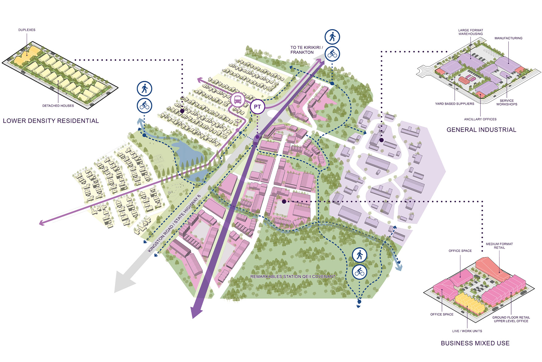
Spatial planning typically incorporates mapping to spatially show inputs (existing opportunities and constraints) and outputs (new projects and future development areas). The maps and plans demonstrate a process of consideration and decision-making that provides direction through a clear visual output to move forward from.
What are spatial planning inputs?
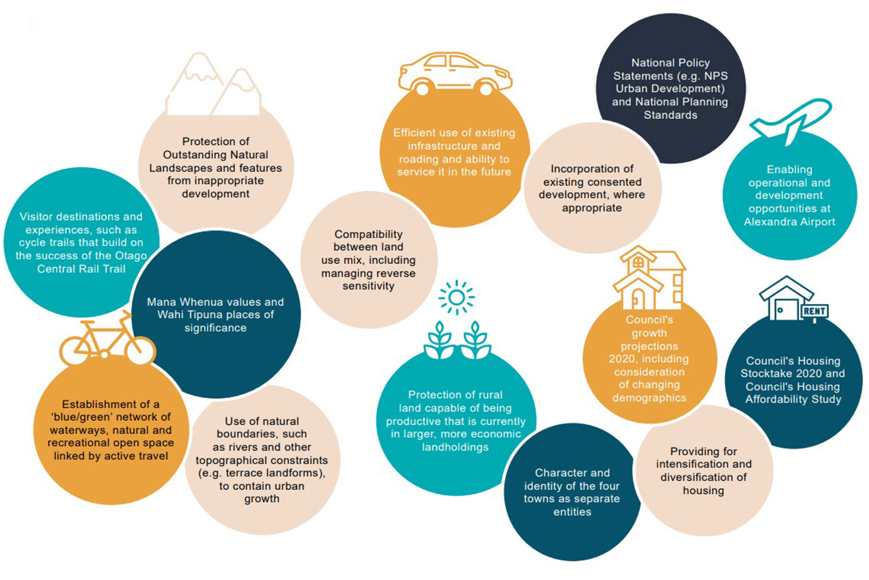
Inputs to a spatial plan are any existing constraints and opportunities. This includes objective data, such as demographic and geographic information; and existing infrastructure, like roads and utilities. Spatial planning inputs also include studies and analysis that inform and impact guide the spatial planning process, such as:
- Landscape and Coastal Natural Character Studies;
- Ecological Assessments and identification of Significant Natural Areas
- Cultural Assessments
- Community Engagement
- Existing legislation, statutory plans, or policy statements also influence and inform spatial plans.
Boffa Miskell has a long history of assisting Councils with studies and analysis that inform the spatial planning process. This work involves core Boffa Miskell disciplines, including landscape planning, ecology and biosecurity, planning and transport planning, cultural advisory, engagement, and climate change, assisted by our GIS specialist team.
Our cross-disciplinary expertise means that spatial planning inputs can be comprehensively addressed in an integrated and coordinated manner. The Boffa Miskell team can assist clients in understanding complex matters that need to be addressed in the spatial planning process.
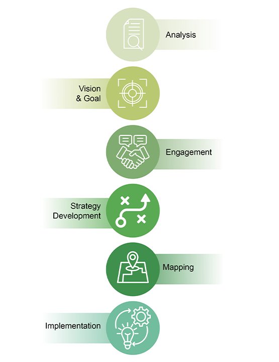
What is the spatial planning process?
Spatial planning is about proactively creating a long-term, comprehensive, forward-looking strategic framework for growth and changes in an area over time. Spatial plans are not a response to a short-term ‘problem’ or market demand.
Instead, they provide a structured approach to addressing complex development challenges by integrating a wide range of considerations and addressing matters holistically. The spatial planning process begins with a clear geographic scope and a thorough understanding of the existing context, including current land uses, infrastructure, and community needs.
Looking at complex issues in an integrated and coordinated manner is a strength of the Boffa Miskell team. We work collaboratively to assist clients in understanding the wide range of relevant matters that need to be addressed in the spatial planning process.
Along with our multi-disciplinary capabilities, Boffa Miskell consultants are experienced in integrating community input and co-design into the spatial planning processes through facilitation of workshops, engagement, and consultation.
In addition, we regularly work with other specialist teams in relation to natural hazards, infrastructure and demographics, with our engagement specialists assisting with the facilitation of community input. This interdisciplinary approach means that complex issues can be comprehensively addressed through the spatial planning process, taking into account key aspects such as managing population growth and natural hazard risks.
The spatial planning process incorporates constraints analysis to identify environmental, cultural, and physical limitations. Through the designation of land uses and the layering of key systems , such as Blue-Green Networks, transport, and infrastructure, a spatial plan creates a coherent framework for sustainable development over a period of years, or decades.
Finally, a spatial plan includes a clear implementation and staging strategy to guide delivery over time and ensure alignment with funding mechanisms and statutory planning instruments. This comprehensive approach ensures that spatial plans are both visionary and practical, enabling coordinated, place-based decision-making.
How are spatial plans implemented?
Once a spatial plan is in place, there are a range of ways in which it is integrated into Council business and regulatory functions.
For Regional Spatial Plans it is likely the key implementation methods will be through regulatory plans (the new forms of regional and district plans) as well as through Long Term Plans and Regional Land Transport Plans. There will also be a range of other implementation methods such as smaller-scale area and development plans, reserve management plans, and infrastructure plans.
Discrete projects can also be part of implementing a spatial plan, in response to specific identified opportunities or issues. These could include a streetscape upgrade in the town centre to accommodate a changing population, designating areas that will be set aside for development or protection, or undertaking a longer-term staged programme of infrastructure improvements.
The Boffa Miskell team have considerable experience in assisting with the design and development of these implementation tools, particularly in the development and change of district and regional plans, management plans and infrastructure planning projects.
View our spatial planning capability statement.